Showing posts with label DNR. Show all posts

Wednesday, January 14, 2015

TWIN Track-A-Thon


Eastern Grey Wolf
Although I've been tracking animals for as long as I can remember, it's usually been as a side interest to whatever other outdoor excursion I'm on- hunting, cross country skiing, mountain biking or snowshoeing. Grooming ski trails late at night always offers great opportunities as well and sometimes the hours last a little longer if I'm distracted by minutes old fresh animal sign. If anything, those days now feel like the minor leagues-I knew tracks pretty well, but after completing tracking certification and becoming a Volunteer DNR tracker earlier this year, it's more like I graduated to the big show. Now, I need to be very precise, I need to verify, look for evidence and confirm what I'm seeing in the snow and keep detailed records....yeah, this is a new ball game.

This past weekend TWIN (Timber Wolf Education Network) held their annual “Track-A-Thon” in the central forest region of Wisconsin-the southern end of wolf territory in the state. Headquartering out of the Sandhill Wildlife Area near Babcock, TWIN members meet, were given assignments on tracking areas, discussed recent sign and headed out to spend a day surveying their blocks. TWIN focuses on science-based wolf education and provides outreach through wolf ecology workshops each winter. Most members are also involved with the Wisconsin DNR volunteer carnivore tracking program and results from the Track-A-Thon were forwarded to that effort.

The WDNR runs the most extensive tracking surveys in the country, starting in 1977 for fur bearing animals. Wolf tracking began formally in 1979 and the current volunteer program of conducting wolf and carnivore surveys started in 1995. The intention of the study, in addition to determining numbers and territories of wolves, is also to keep tabs on other medium to large carnivores and determine if rare species like Canada lynx, wolverine or cougar also exist in the state.

Bob Cat
Participants are asked to complete a track training course, attend a wolf ecology class sponsored by the DNR, Timber Wolf Alliance or TWIN, complete a mammal test and conduct a minimum of three surveys submitting their results per guidelines to the DNR.

Being new to the group, I was eager to meet and learn as much as possible during this day long event. Sandhill is about 30 miles east of my usual tracking area, so I decided to start my survey on some unexplored forest roads nearer that side of my block. I'd been tutored on using some high tech gear-an external GPS unit, which blue tooth connects to my ipad loaded with various off-line maps. The DNR tracking surveys follow specific protocol and one needs to carefully record the survey route and milage. I found the technology on the dash of the truck advantageous, and if needed, I could flip through different charts on the ipad, looking at everything from topo maps to satellite imagery. Track locations could be added with waypoints and details typed in on the fly. That said, there is also room for the old school methods. Hand written notes on every track observed were scribbled with pencil in a notebook and old fashioned folding wood rulers did the measuring. I do carry a digital camera as well and police evidence scales (rulers) to grab images of particularly interesting tracks or sign.

The track-a-thon was lucky enough to fall about 36 hours after the last snowfall-prime time to get good tracks. Windy conditions the previous day also helped in aging-aiding trackers in determining how recently animals passed by. If roads hadn't been plowed, then it's a much easier task to spot sign. More traveled routes, require an even slower survey speed. My average pace was under 8 mph for the five and half hours in the field. All larger carnivores are recorded-every coyote, bobcat, fisher and wolf track is noted, located on a map and direction of travel indicated.

Coyotes are ever more present and jumping in and out of the truck to check their prints and document them is quite a task. It's when there is something different about a track, the size, the gait pattern, how the snow is scuffed, that makes tracking exciting and I'm quick to exit the warm cab. Deer prints are pretty easy to spot and dismiss-they wander, have a wide straddle and leave a collar of snow around their steps.

Bob Cat
My first 2 miles seemed to take forever-frequent coyotes criss-crossing the road and plenty of deer sign kept the pace slow. Hitting a forest road with all fresh snow and no other vehicle traffic was divine for surveying. Within another mile, a tell-tale large, consistent and widely spaced imprint suggested a wolf. Excitedly jumping out of the truck, my thoughts were confirmed-perfect 4.5” canid track-an Eastern Grey Wolf. Although we are recording all carnivores, wolves are what we most want to keep tabs on, so this was a great find so early in my survey. Following the trail into the woods off road, there was good reason why “he” was here-whitetails had the whole area tore up feeding on acorns-good habitat for both animals. The wolf continued for some distance, seemingly having places to get to south of my position, so I continued checking roads and dead end flowage trails for more sign.

Another hour passed and I hit the trackers mother-load (well, we do get excited about finding different species!)- A wolf, also traveling south, a large bobcat and just a ¼ mile down the same lane, a Fisher, bounding down the road before veering off to bop from tree to tree. It's interesting that the snow covered roads can be a blank slate for miles and all of a sudden, you collect a bunch of tracks all at once.

Slow miles continued for another hour on pristine drifted roads until spotting a day old track. The wolf had followed a logging road and I back tracked it for a mile to the point it entered from a large marsh. Another fresh track had crossed this, so I had plenty of information to record and GPS. Soon, things became crazy-several sets of tracks crossed the road different directions and I needed to investigate further into the woods to figure out where they came from. One group of three seemed to have found something interesting under a brush pile-the tracks had the ground pounded smooth, but there was no other sign. A bit further, a pair of tracks traversed the lane in an opposite direction and left behind a RLU (raised leg urination)-a good indication this was a alpha animal in the pack. Scribbling notes and drawing arrows on maps, all the sign seemed to point at just a few animals that were going back and forth in a small area. In any regard, it was fun and challenging to decipher all clues left on this short section of road.

Wiley E. Coyote
Sometimes it's a matter of feast or famine. As interesting as that flurry was, the next 2 hours passed with only a couple coyote prints, a ton of deer sign and another bobcat trail to keep me busy. My truck slithered down more narrow rutted paths, but for the most part, the snow was undisturbed for the final two hours.

Volunteer trackers are asked to travel 20-30 miles each outing, so with 26.5 recorded and completing a loop in the state and county forest, I ended the survey. From here it was a long drive back to Sandhill where we would tabulate results and do a post survey debriefing, along with just visiting and finding out what the other participants discovered. Most of the TWIN members have many years experience under their belts and had a good handle on what we'd find. On the wolf tally, some individuals and packs were located where expected, while others seem to have disappeared, fueling discussion within the group for possible causes.

Later in the evening Retired wolf biologist Dick Thiel and Ray Leonard, TWIN chairperson, lead a discussion on the recent re-listing of the eastern grey wolf to the endangered species list. The day was a great opportunity to make connections with other TWIN members, practice the craft of tracking and spend a day outdoors in the winter, always a good thing and something I'll look forward to again.


Monday, July 8, 2013

Wolf Flight

Pre-Flight Check

Pilots take no special joy in walking. Pilots like flying.
Neil Armstrong

Probably no quote better describes Beverly Paulan,  a Lead Pilot for the Bureau of Forestry Protection in the Wisconsin Department of Natural Resources in Eau Claire.  She does spend her share of time on the ground-perhaps during Karner Blue Butterfly habitat surveys or volunteer hours tracking bats, but the sky is her home to be sure.

The opportunity to join her on a wolf survey flight was one I just couldn’t pass up as I’ve taken a great interest in them over the years-especially several radio collared ones in my home area recently.  I’d hoped to do a winter flight at some point for the chance to photograph them from the air, but a summer flight would prove very rewarding as well.  

Before joining the Wisconsin DNR as a pilot in 2010, Beverly was a full time flight instructor, charter pilot and also worked with cranes at “Operation Migration.”  As she told me, she’s “loved flying as far back as I can remember.”  It took awhile, but landing the DNR job as a pilot, (pun intended)with her love of wildlife and the outdoors, was a perfect fit.  “I have the best office in the world!” she happily shared.  Besides wolf radio tracking from the air, she and fellow Eau Claire pilot Leo Bunderson, also fly swan, wintering duck and eagle surveys, Whooping crane studies, Otter counts, fire protection and monitoring Gypsy Moth spraying. 

Some of the flights, especially the bird surveys, can be “challenging” to say the least.  Low altitudes, sometimes just 80 feet above the deck, are required of pilots in order to count nesting birds, eggs or the progress of hatched eaglets, “colts” (cranes) or cygnets.  “Be careful, because the ground can come up and smite thee!” is a serious word of advice from her father.  Besides the normal array of radio and cell towers, it’s becoming more common to come upon portable, non-licensed towers popping up 100’ which can pose a real hazard to these fliers.  

Although Whooping cranes are fitted with radio collars, they do not have mortality signals like wolves do (or other collared mammals), so visual confirmation is needed when monitoring them-requiring a balance between getting low and close and not causing any change in the birds demeanor, something very important to Paulan.  “Whether a wolf or crane, I don’t want to see any change of their normal behavior when observing them-that’s just my principle when flying close.”

On our flight, we left the Chippewa Valley Regional Airport, which is the base of operations for DNR flights in this sector of the state.  The goal was to pinpoint the locations of 6 wolves that were transmitting radio signals and record their movements from earlier flights.  Especially important were checking on two wolves collared the previous weekend to be sure they were doing okay.  Every collar is assigned a frequency and every wolf designated a number (and sometimes a nickname by researchers).  “I know I shouldn’t get attached to an animal, but you do.”  Beverly mentioned.  “An animal you’ve kept tabs on for a long time or one that went off air and returned much later can cause a little celebration in the cockpit!” 

One such animal for me was “Seca” or #795, a wolf trapped and collared last year when I joined a monitoring team and had the privilege to photograph.  Since his location was near my home, a biologist friend kept me apprised of how he was doing and his movements in the area.  We were all pleased he appeared to be doing well and came through the inaugural wolf hunting season this past winter.  Unfortunately, earlier this summer, Seca “went off the air” and no mortality signal was received.   Weekly flights turned up no further sign of him and Paulan shared that most likely he was the victim of “lead poisoning” or illegal shooting.   The animal is poached and the expensive collar quickly destroyed, leaving valuable scientific research unfinished.  “Some areas of the state are particularly difficult to keep a wolf alive,” a hint of frustration in her voice.  Paulan also shared that studies are showing there is more suitable habitat for wolves than previously thought and numbers seem to be stable.  Packs tend to be smaller as is their territory and at times overlap, but they seem more tolerant than wolves in other parts of the country.  Wolf surveys, hunt harvests, car kills and other causes of death are used to determine populations and goals.  What’s not known is how many animals, like Seca, just “disappear.”

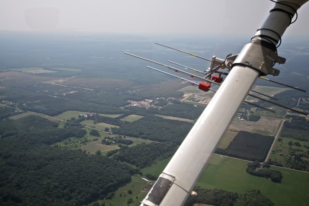
As our flight headed east, the first wolfs’ transmission was quickly picked up very near its previous GPS position.  Each wolf (and crane or other surveyed animal) have a GPS waypoint from their last known fix, making it easier to quickly find a signal.  It’s pretty amazing to see Beverly fly the plane, flip switches between two antennas on either wing, cradle the transceiver adjusting squelch (sensitivity to a signal), punch in a new GPS point and hand write a note in her observation folder….almost all at the same time.  Dropping altitude and circling tighter usually was rewarded with a comment like “Yep-he’s right under us.” Or “somewhere in that patch of pine.”  Slight nudges of the pedals or a touch to the yoke, set us on course to the next wolf.

If it’s only a weak transmission-perhaps from an old collar and batteries, we’d ascent higher to try and catch the cone-like signal to narrow in on the location.  Dropping down low would then pinpoint the exact spot within a hundred yards or closer.  I’d not flown in such a small craft like Paulan’s  Cessna 172 but tolerated the ever tightening steeply banked turns required to hone in on a fix-kinda fun, actually!

Flying at just 3000 feet above the landscape was such a great perspective-particularly since part of our flight was over county forest I know well.  Seeing trails, forest roads and wetlands from above kept my head glued to the window, camera at the ready.  Recording one wolf location after another, we continued south east and made a slight detour to check on a whooping crane occupying a nest.  The bright white speck was easy to pick out from the surrounding lush green marsh, and it’s posture told Beverly that the eggs were not hatched as of yet.  Both male and females will help incubate the eggs she added.  Trying to photograph from the plane proved to be difficult- a lot of movement and we did stand off a bit so as not to disturb the nest.

Two wolves occupy territory within the Air National Guard’s Hardwood bombing range and surrounding wildlife area south of Babcock, and yes, animals have been lost here because of military training.  Beverly radioed ahead to Camp Douglas to confirm the range was not” hot” (open for training) and safe to enter.  It was rather odd to see tanks, containers and aircraft randomly scattered in the thick forest below in various stages of destruction.  Apparently, it still can be home for wildlife, as the two wolves here were found and we headed back out. I wished inside, they’d perhaps move to a safer habitat. 

The newly collared wolves were pinpointed and I perceived some relief from Paulan, “It’s always comforting to get that first signal after collaring, a strong signal tells us everything is working well.”  I was surprised how far one of them had moved-maybe 4 or 5 miles from the capture site.  “Actually, I’m happy to see them on the move like that-it tells us they are healthy and doing well.” commented Paulan.  Sometimes successive flight observations can also help gauge how they are recovering from an injury, for instance.  One subject, who had suffered leg trauma, visibly could not use that limb at first.  Each week, Paulan observed him recover slowly, a limp, then gradually full use of leg.  It also told researchers that he was with a supportive pack or he would not have survived.

Our return flight took us over the Sandhill Wildlife Area, where we had a chance to observe bison settling down in their sand wallows-the giant animals easy to pick out below.  Small flowages I’d duck hunted in many years past were nearby and I recognized some here within Sandhill.  It was amazing how quickly you can get from point A to point B in this small plane, yet we were only traveling at 90 or so knots.  Landscapes take on a whole new look, the topography isn’t always obvious.  I’d pick out features like the Black River, Lake Arbutus or Lake Eau Claire to get my bearings-Beverly used major road ways.  Near Augusta, one easy landmark contrasting from the surrounding Amish farms was a massive frac sand mine with a mile plus conveyor moving sand to a plant and rail road spur.  From the air the huge holding ponds nestled right next to small farms and cropland could easily be distinguished.  How the influx of these mines must have changed the living environment here.

After gently setting down back in Eau Claire, we had a chance to review parts of the flight, their profession as pilots and some like minded discussion on wide ranging topics, from hunting to public service careers.  What became clear is that for Paulan, being a DNR pilot is not so much a job, but rather a calling-for she is just as passionate about the environment, outdoors and wildlife and their well being as she is about flying.  Although Armstrong said-  pilots like flying,” and Paulan does, she also takes very seriously why she is in the air and what her work provides for biologists, scientists and anyone who loves Wisconsin’s outdoors.


Smith: Tracking surveys remain critical part of DNR's gray wolf population estimate in Wisconsin

  Smith: Tracking surveys remain critical part of DNR's gray wolf population estimate in Wisconsin Tracking surveys by DN...