
Backpacking the Porcupine Mountains Wilderness
“Thousands of tired, nerve-shaken, over-civilized people
are beginning to find out going to the mountains is going home; that wilderness
is a necessity...”
― John Muir
― John Muir
I believe Muir was correct in his opinion that “wilderness
is a necessity” A break from our “civilized”
world, a chance to be in a place that time has not changed, our ancestral roots so to speak. Sometimes we need to seek out and
experience living a day or two where all modern safety nets and/or distractions
are far removed. Although
Wisconsin does have seven designated Wilderness areas (Blackjack
Springs Wilderness, Gaylord Nelson Wilderness,
Headwaters
Wilderness, Porcupine Lake
Wilderness, Rainbow Lake
Wilderness, Whisker Lake
Wilderness, Wisconsin Islands
Wilderness) they tend to be of smaller parcel
size and scattered throughout the northern part of the state. For a larger unbroken wilderness
experience, one just has to venture across the border into the U.P. to visit
the Sylvania Wilderness and
Porcupine Mountains.
The “Porkies,” Michigan's largest state park and designated
wilderness comprises 60,000 acres of old growth forest along Lake Superior and
is just north of the Wisconsin border. Besides the shear natural beauty of this
park, friends Mark Haferman from Marshfield (backpacking instigator) and Dave
Borman of Ladysmith and I hoped to explore some of the 87 miles of backcountry
hiking trails spread thought the forest.

As with all good trips, a plan is formulated weeks ahead (more
or less) and there are always a few new gadgets to buy-one always needs a good
excuse for fresh gear! New boots,
tents, sleeping pads and an ample supply of freeze dried food started arriving
by Fed-Ex at front doors leading up to our hike. Mark is our most experienced backpacker and has made the
trip to the “Porkies” a few times before.
We usually rely on his good judgment to plan our itinerary
and work out the details of the trip.
With one of the worlds largest freshwater lakes it’s doorstep, we'd
planned to spend at least one or two days along it's shore. Mark had been driven back from the big
lake previously by cold winds on shore, so we'd hoped the weather would be more
cooperative.
As
it turned out, weather would not be our biggest challenge. Warm temps and a small chance of rain
lead us to tackle the "Lake Superior Trail"
first, a 9+ mile trail starting high above the water at the Lake of
Clouds. To access the trailhead,
we actually had to hike a steep blacktop park road down to the trail entrance
and into the dark primeval hemlock forest. We’d guessed the trail would follow along the shores of
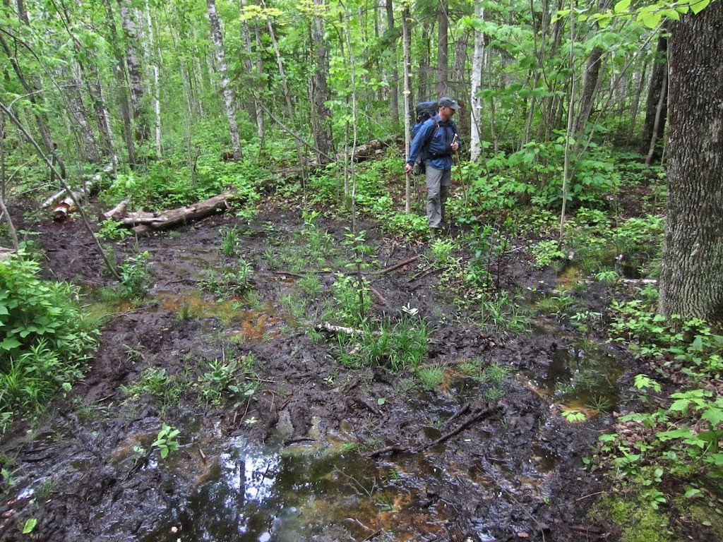
the lake, making for spectacular views of the big water. Instead, the majority of the route lies
deep in the forest, starting in rocky shale downhills, then into wet muddy
sections, a challenge to navigate.
At the midpoint a spur trail led us to the lake and the first campsite. It was at that point we discovered what
would be a real test.
According to locals (we found out
later) there are peak times for the ferocious black flies (“fish flies” “sand
flies” *#$@% flies etc.) and we were unlucky enough to hit them in swarms. (For another great account here: http://personaldiatribes.wordpress.com/2010/07/06/black-flies-in-the-up-a-k-a-my-15-minutes-of-living-hell/) We quickly retreated to the mosquitoes
inland, which were a bit more tolerable (though very bad by all
standards). Stopping for a break,
lunch or to even zip on lower pants legs was all about impossible. Five hours into our trek, we really wondered
what our options would be as the trail headed back to the lake again. More bug spray was showered on, head
nets donned and our pace quickened to little avail. Even reaching the Little Carp River trail intersection
provided no relief and slight winds off the water did little to deter the
little buggers.
At this point, our only option was
to head upstream and hope the deep hemlock forest would be less suitable
habitat for the bugs and we could at the very least quickly pitch a tent and
hide. A mile or so along the
river found our strength fading-we’d run out of water (no chance to stop and
filter during the day) and hiked much further than planned. We found a campsite along the beautiful
Big Carp River and decided this would have to be it. Surprisingly, the ‘sqeetos were not to bad, and we all
breathed a sigh of relief.

This is wilderness, so one has to take the good and the bad. My thoughts during the day at times
went back in time to those who actually lived here-a 100 or 200 years ago and how
difficult life would have been.
Much tougher than us I know.
The campsite along the rapid filled Carp was so perfect that the swarms
of insects were soon forgotten.
Feet were soaked in the ice cold water, a good meal prepared and a few
hours chatting around the campfire ended this testing day. Tomorrow, a decision would have to be
made on the remainder of the trip.
The Big Carp River trail in the
old growth Hemlock sections are beyond what a camera can possibly capture
(though I tried) and constantly amazed us. Day two had us heading upstream past small waterfalls and
through dark cathedral forest- a great way start even with weary legs. Several hours later we needed to
determine which trail to continue on.
The Big Carp would be 3 more hours of challenging climbs to the
escarpment and end at Lake of the Clouds, while the “Correction Line trail”
would end at Mirror Lake (the parks highest lake). We’d met several groups of
hikers along the way, (one band, loaded down with pistols on hips and bowie knives
strapped to chests….really???) and all
reported the bugs were thick at Mirror Lake. Tired of getting bit, we chose heading uphill instead.

We again found ourselves in
beautiful Hemlocks and though the trail steadily tilted upward and the legs
felt it, the hike was great. Frequently stopping, just to look and see, this was the best trail we’d been on. The escarpment high above Lake Superior
here is a strenuous climb up to about 1400 feet. With heavy packs on, it was one-foot-in-front-of-the-other
until reaching the top. In the
end, it was well worth it-the views cliff side were breathtaking. It would be another hour or so until we
reached the Lake of the Clouds observation area in the distance. Not quite done
with us yet, the trail played cruel jokes on us by descending and re-climbing a
few times along the way. Day
hikers, with nary a waterbottle along would fly by, somehow (in our minds) not
worthy of this trail.

Muir spoke of places like this
as “home” and in some primitive way it is. No conveniences, no cell calls or texts-no help or aid if
something should go wrong. The
late "Dick" Proenneke (Alone in
the Wilderness) once stated that you do
everything very carefully-a cut or fall could be life threatening-good
advice. We were deliberate
to pick good foot placements on wet slippery hills and take our time. Although our time spent in the
backcountry here was limited, it was satisfying to be tested and challenged-not
always something that happens in our daily modern life. This big block of roadless territory is
a place we’ll return to for it seems we have unfinished business and more life
to live there.
“To those devoid of
imagination a blank place on the map is a useless waste; to others, the most
valuable part.” -Aldo Leopold

33303 Headquarters Rd.
|
Recreation Passport Required: Yes
|
Ontonagon, MI 49953-9087
|
Approximate Size: 59020 (Acres)
|
Phone Number: (906) 885-5275
|


