Showing posts with label hiking. Show all posts

Tuesday, July 1, 2014

The "Porkies"


Backpacking the Porcupine Mountains Wilderness


“Thousands of tired, nerve-shaken, over-civilized people are beginning to find out going to the mountains is going home; that wilderness is a necessity...”
John Muir

I believe Muir was correct in his opinion that “wilderness is a necessity” A break from our “civilized” world, a chance to be in a place that time has not changed, our ancestral  roots so to speak.  Sometimes we need to seek out and experience living a day or two where all modern safety nets and/or distractions are far removed.  Although Wisconsin does have seven designated Wilderness areas  (Blackjack Springs Wilderness, Gaylord Nelson Wilderness, Headwaters Wilderness, Porcupine Lake Wilderness, Rainbow Lake Wilderness, Whisker Lake Wilderness, Wisconsin Islands Wildernessthey tend to be of smaller parcel size and scattered throughout the northern part of the state.  For a larger unbroken wilderness experience, one just has to venture across the border into the U.P. to visit the Sylvania Wilderness and Porcupine Mountains.

The “Porkies,” Michigan's largest state park and designated wilderness comprises 60,000 acres of old growth forest along Lake Superior and is just north of the Wisconsin border. Besides the shear natural beauty of this park, friends Mark Haferman from Marshfield (backpacking instigator) and Dave Borman of Ladysmith and I hoped to explore some of the 87 miles of backcountry hiking trails spread thought the forest. 

As with all good trips, a plan is formulated weeks ahead (more or less) and there are always a few new gadgets to buy-one always needs a good excuse for fresh gear!  New boots, tents, sleeping pads and an ample supply of freeze dried food started arriving by Fed-Ex at front doors leading up to our hike.  Mark is our most experienced backpacker and has made the trip to the “Porkies” a few times before.  We usually rely on his good judgment to plan our itinerary and work out the details of the trip.  With one of the worlds largest freshwater lakes it’s doorstep, we'd planned to spend at least one or two days along it's shore.  Mark had been driven back from the big lake previously by cold winds on shore, so we'd hoped the weather would be more cooperative.

As it turned out, weather would not be our biggest challenge.  Warm temps and a small chance of rain lead us to tackle the "Lake Superior Trail" first, a 9+ mile trail starting high above the water at the Lake of Clouds.  To access the trailhead, we actually had to hike a steep blacktop park road down to the trail entrance and into the dark primeval hemlock forest. We’d guessed the trail would follow along the shores of the lake, making for spectacular views of the big water.  Instead, the majority of the route lies deep in the forest, starting in rocky shale downhills, then into wet muddy sections, a challenge to navigate.  At the midpoint a spur trail led us to the lake and the first campsite.  It was at that point we discovered what would be a real test.

According to locals (we found out later) there are peak times for the ferocious black flies (“fish flies” “sand flies” *#$@% flies etc.) and we were unlucky enough to hit them in swarms.  (For another great account here: http://personaldiatribes.wordpress.com/2010/07/06/black-flies-in-the-up-a-k-a-my-15-minutes-of-living-hell/)  We quickly retreated to the mosquitoes inland, which were a bit more tolerable (though very bad by all standards).  Stopping for a break, lunch or to even zip on lower pants legs was all about impossible.  Five hours into our trek, we really wondered what our options would be as the trail headed back to the lake again.  More bug spray was showered on, head nets donned and our pace quickened to little avail.  Even reaching the Little Carp River trail intersection provided no relief and slight winds off the water did little to deter the little buggers.
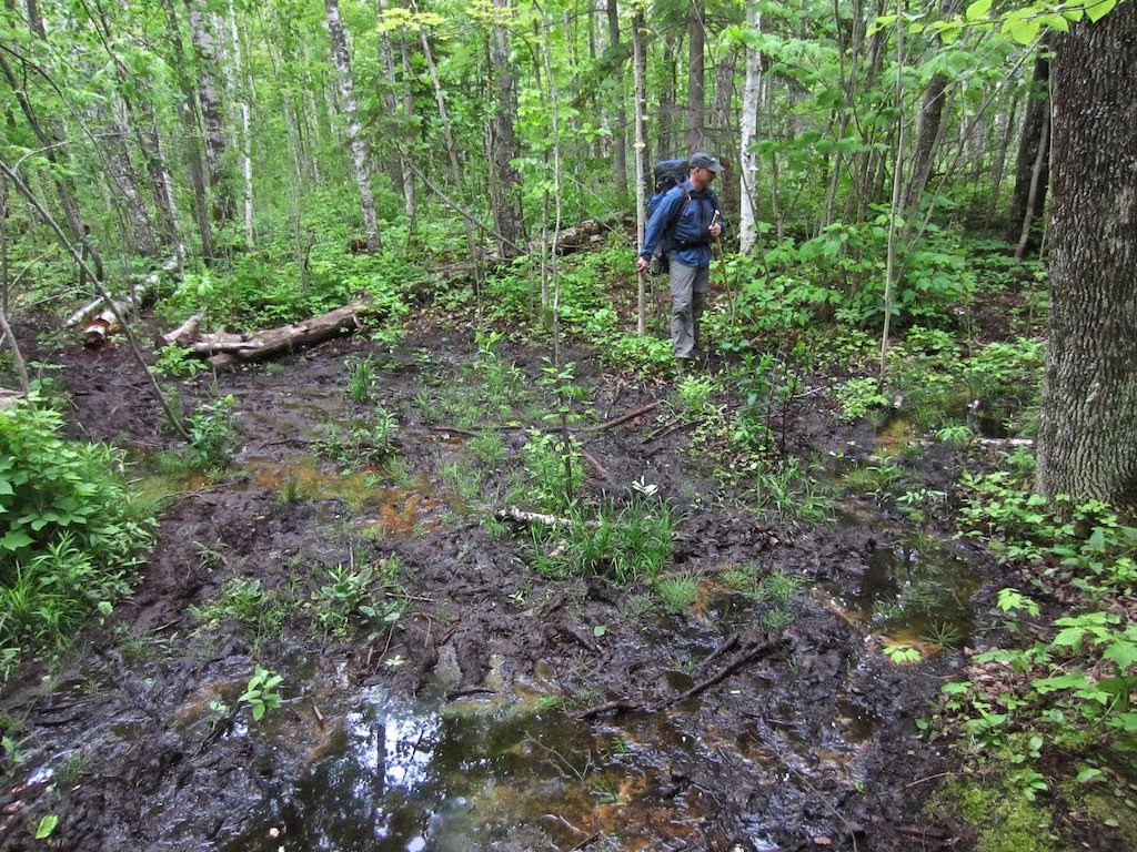
At this point, our only option was to head upstream and hope the deep hemlock forest would be less suitable habitat for the bugs and we could at the very least quickly pitch a tent and hide.   A mile or so along the river found our strength fading-we’d run out of water (no chance to stop and filter during the day) and hiked much further than planned.  We found a campsite along the beautiful Big Carp River and decided this would have to be it.  Surprisingly, the ‘sqeetos were not to bad, and we all breathed a sigh of relief.

This is wilderness, so one has to take the good and the bad.  My thoughts during the day at times went back in time to those who actually lived here-a 100 or 200 years ago and how difficult life would have been.  Much tougher than us I know.  The campsite along the rapid filled Carp was so perfect that the swarms of insects were soon forgotten.  Feet were soaked in the ice cold water, a good meal prepared and a few hours chatting around the campfire ended this testing day.  Tomorrow, a decision would have to be made on the remainder of the trip.

The Big Carp River trail in the old growth Hemlock sections are beyond what a camera can possibly capture (though I tried) and constantly amazed us.  Day two had us heading upstream past small waterfalls and through dark cathedral forest- a great way start even with weary legs.  Several hours later we needed to determine which trail to continue on.  The Big Carp would be 3 more hours of challenging climbs to the escarpment and end at Lake of the Clouds, while the “Correction Line trail” would end at Mirror Lake (the parks highest lake). We’d met several groups of hikers along the way, (one band, loaded down with pistols on hips and bowie knives strapped to chests….really???) and all reported the bugs were thick at Mirror Lake.  Tired of getting bit, we chose heading uphill instead.

We again found ourselves in beautiful Hemlocks and though the trail steadily tilted upward and the legs felt it, the hike was great. Frequently stopping, just to look and see, this was the best trail we’d been on.  The escarpment high above Lake Superior here is a strenuous climb up to about 1400 feet.  With heavy packs on, it was one-foot-in-front-of-the-other until reaching the top.  In the end, it was well worth it-the views cliff side were breathtaking.  It would be another hour or so until we reached the Lake of the Clouds observation area in the distance. Not quite done with us yet, the trail played cruel jokes on us by descending and re-climbing a few times along the way.  Day hikers, with nary a waterbottle along would fly by, somehow (in our minds) not worthy of this trail.

Muir spoke of places like this as “home” and in some primitive way it is.  No conveniences, no cell calls or texts-no help or aid if something should go wrong.  The late "Dick" Proenneke (Alone in the Wilderness) once stated that you do everything very carefully-a cut or fall could be life threatening-good advice.   We were deliberate to pick good foot placements on wet slippery hills and take our time.  Although our time spent in the backcountry here was limited, it was satisfying to be tested and challenged-not always something that happens in our daily modern life.  This big block of roadless territory is a place we’ll return to for it seems we have unfinished business and more life to live there.

“To those devoid of imagination a blank place on the map is a useless waste; to others, the most valuable part.” -Aldo Leopold


33303 Headquarters Rd.
Recreation Passport Required: Yes
Ontonagon, MI 49953-9087
Approximate Size: 59020 (Acres)
Phone Number: (906) 885-5275


Wednesday, January 1, 2014

2013 In Images

Sunset-North Dakota
End of the year.  I could look ahead and decide to tackle some big photography project, like a 365 or something, but instead, I decided to just look back.  I've done this  for years now and it's always interesting to relive little things as I flip through the photographs.  I didn't strictly stick to one per month and they are not all great photos.  They're selected because of why we make pictures.  To make something beautiful, to relive a memory and to record an important event.  More or less chronological, enjoy the past year in pictures.
Deep Winter

Happy Holidays!

The Joy of Crust Biking

Pedaling the Sweaty Yeti

Head Coach Melting in South Korea

The Big Snow
The Sandhills are Early


Sturtz Prairie in Winter


East Snow Creek Turkey Woods
Horn Lake Camp

Isle Royal Beach

Gnomefest Derby

Oxbo Paddle

Molly in Blind-North Dakota

Frustration

Happy Trey

Dave Spreading Deeks

Snowy Owl Invasion of 2013

Trey and Gpa

Lights and Shadows

Friday, August 30, 2013

Indian Creek-Ice Age Trail

Indian Creek Headwaters

 “My favorite thing to do is to go where I’ve never been.” – Diane Arbus

I find that a very true statement-though there is nothing wrong with returning to favorite places as well.  A “place” I’d never been is almost all of Wisconsin’s Ice Age Trail, although I’ve been able to knock off a couple segments this summer.  The IAT is currently undergoing an update of it’s field guide, an ongoing process to be sure maps and segment descriptions are current.    The update procedure involves editors hiking  sections of trail, noting any changes from previous descriptions and adding additional information.  It’s also important to describe the “feel” of the trail-intangible things that help characterize hiking a segment.  Checking map accuracy, GPS waypoints and local points of interest are also part of the field editors duty.

A last minute request to hike a segment in Polk County in North West Wisconsin was forwarded my way in hope it could be completed before a September 1st deadline for the field guide.   The 140 mile drive from home could fit into an early morning journey on a  day off, so I agreed and hit the road before things got too hot during a recent heat wave.   At 4:00am, the traffic, even on I-53 headed north, was light and I was able to reach the segment terminus as daybreak arrived.  The plan was to lock my mountain bike there, drive back around west to the trailhead, hike the section of trail taking notes, waypoints and photographs and pedal the bike back to the car. 

The Indian Creek Segment of the IAT is the eastern portion of what once was the much longer McKenzie Creek Segment.  There are ample parking areas at both ends of the trail and it’s well marked and maintained.  All IAT trails have yellow blazes-either painted, plastic tags on trees or in open areas, carsonite posts, which make navigating easy.  In some of the lower fern covered areas of Indian Creek, I’d check the blazes often to stay on course.  This segment isn’t as glacially featured as others, with the first and last part of the trail fairly flat and easy, but there are some good glacial hummocks at the midpoint challenging hikers up steep climbs and descents. 

The majority of the trail is on public land and the forest is mostly managed for larger stands of hardwoods by select cutting.   Crossing 30th st. (a gravel town road) marks the midpoint and the start of a trek through open woods and dry (at this time) rocky creek beds.  A short ridge climb puts the trail above a small picturesque water lily filled lake, the headwaters of Indian Creek, which flows north.  The habitat is ideal for wildlife, and I saw several deer and grouse and plenty of black bear sign-rotted stumps tore apart, fence posts raked and chewed on and berry filled scat.  It is berry season, so it really wasn’t a surprise when as I stopped to make a photo, a movement of black caught my eye a short distance away.  A year or two old bear slowly ambled through the brush toward me, unaware I was fumbling with the zoom on my camera.  Realizing he’d need to be too close for a good image, I decided it’d be wise to talk loudly to announce my presence, at which point he stared, turned and trotted off.   A pretty neat encounter to say the least!

The final mile of the trail consists of narrow hand carved trail, a short bridge crossing and an open mowed meadow, finishing at the trail terminus parking lot. From this point, the IAT continues a 1/2 mile south on Cty. Hwy. E, and then climbs into the woods east on the Sand Creek segment into Barron County. The bike was waiting and I had a 7 mile hilly ride ahead of me to return to the start-not a bad thing,  my legs enjoying the change-spinning pedals and producing a little breeze on this hot morning as a relief.

 The trailhead and waiting car are within the McKenzie State Wildlife Area off Ct. Hwy. O, perhaps another place I’ve never been to explore another time.  For now, a quick change, a look over my notes and a slow drive back, stopping to investigate other nearby points of interest for the trail guide.

Location: The Indian Creek Trailhead is located approximately 19 miles north west of Cumberland between Cty. Hwys O and E.  in Polk County.  The trailhead is also accessible 10 miles east of Fredric, WI off Cty.Hwy. W. 
 

Saturday, August 17, 2013

Isle Royale Wilderness


I think each of us have a bucket list of some sort-some write it down, some have it floating around in our soul, maybe constantly changing from time to time.  I have one I guess when I think about it, usually involving something outdoors.  Hike the Grand Canyon top to bottom, build a wood kayak or backpack a wilderness.  At least I can check one off, not that I won’t go back- the Isle Royale Wilderness is the most re-visited National Park in the states, and I can see why after just returning.  There is something about it and it’s hard to put a finger on exactly.  It doesn’t have over the top features like Yosemite or Yellowstone, but rather something more subtle maybe that is just what connects with some.

As mentioned, Isle Royale sits offshore of Wisconsin, is just 22 miles from Grand Portage MN (our jumping off point), 55 miles from Copper Harbor MI and actually closest to the mainland of Canada. When viewed from a map, the island looks like the eye in the wolf shaped Lake Superior.  Summer to fall, ferry service shuttles park visitors from Minnesota and Michigan (2-5 hours one way) and around the 105 miles of the island coast.  The National Park has a rich history, dating back to native people using the island for copper mining, maple syrup gathering and of course hunting and fishing.  Scandinavian fishermen were among the isle’s more recent permanent settlers, along with loggers, miners and vacationers.  During the 1920s and ‘30s, the national Park Service began establishing a National Park and with most inhabitants leaving the island. 

Nearly all of Isle Royale was officially designated Wilderness in 1976 meaning there is little human impact here besides hiking trails, two main harbors and a few scattered cabins.  That is the real attraction-at least for me.  To be in a place where for almost 70 years or more, nature has reclaimed the land and left it without interference from man. 

Our group of six included 4 rookie backpackers, (myself included if you don’t count Boy Scouts more than a few years ago) and two experienced and returning Isle Royale trekkers.  Close friend Mark Haferman from Marshfield was the real instigator and organizer, pimping me for years about going on this adventure-I finally gave in…fortunately. We made the long journey along the North Shore and jumped on an early morning ferry for the start of what would be a three day backpacking trip.  Visitors are given an introduction to the park upon arrival by Park Service Rangers, register and set an itinerary.

Feldmann Ridge
Most of our packs came in around 40# with all the gear and food for the days ahead and I found it took the first hour each day to get it adjusted just-right to be comfortable.  Day one we hit the Feldmann Ridge Trail, a 8.5 mile hike to Feldmann Lake and our first camp.  Steep ridge climbs with outstanding vistas of the southern part of the island and Lake Superior were part of this section, along with deep spruce forests.  It seemed the forest type changed constantly, so different from what we’d have back in Wisconsin.  Giant Yellow birch dominated the latter part of this hike-trunks so large two of us couldn’t reach around!  At other times, the path also included my least favorite part for Red Elderberry and Thimbleberry plants formed almost an impassible barrier to wade through.  Luckily, the Thimbleberry were in season and quite good and we’d snag handfuls along the way for a treat.  Tired and a bit sore, the effort is always worth it. After making camp, we had a chance to make the short journey to Rainbow Cove, a black sand beach reaching out from the southern most end of the island.  Nothing needed to be said or done there, just 6 tired bodies taking it all in as the sky began to change color.

The plan for day two was to continue to Siskiwit Bay, nine plus miles to the north following Feldmann Ridge, here a dramatic exposed basalt rises above the surrounding forest.  A now abandoned firetower along the way offered a break and a chance to really get some great views of the landscape.  With the island 50 miles long and 9 wide, it’s not quite possible to see it all, but enough to impress.  Our destination was clearly in view but still seemed many hours distant-not at all encouraging to my feet and back!  From the (literally) high point of the segment, we dove down into beautiful solid paper birch forest and then deeper into black spruce bogs, expecting at any moment to encounter a moose, which are fairly common.  The final push was a 2 mile arrow straight stretch we all dubbed “the jungle.”  It appeared to have once been a road or long forgotten tote trail, but now overgrown with brush and berries.  More than once we’d check the narrow worn footpath beneath the vegetation to be sure we still were on track.  It was taxing to say the least and the blue of the bay peaking through the final 1/4 mile was a welcome sight.

Siskiwit Bay
Staying at Siskiwit Bay was a gem of the trip-the bay was a mile wide and stretched northeast forever into the big lake.  Iron colored rock and beach stones covered the shore where we spent all evening after setting up camp.  One can’t quite top ending a hike absorbing the outdoors in a place like this.  Our only company a few shorebirds, ever present gulls, loons and one red fox, intent on scoring a meal.  We filtered water, talked quietly and discussed the daunting route ahead of us as the fire and sky gradually retired for the day.

Mark had set forth the toughest hike for our final day-there are no shortcuts on Isle Royale-once you’re in, you are committed to finishing the route.  He claimed our packs would be lightest on the most challenging day making it easier-I wasn’t so sure. Not really wanting to say good bye to the water, we began what would be a two hours of climbing-the Island Mine Trail ascending 700 feet above Lake Superior.  Island Mine was a failed copper mine established in 1874, operating just 3 years, before abandoning the “town” and one shaft.  A steam boiler, cables and giant geared wheels can still be found here among the tailing piles and offered an excuse to rest and explore before continuing our climb. 

There were many times we were relived to think we’d reached the summit, only to see another pitch through the forest ahead pointing skyward.  There were tricky rock strewn sections and then a short switchback descent-overall a tough hike.  After a break and a granola and jerky lunch we headed for the final section-the beautiful Greenstone Ridge Trail. Isle Royale is well known for it’s moose and wolf studies and here we did spot tracks of both, but with the wolf population on the brink of extinction  (just 9 left on the entire island) chances of seeing one were slim.  Continuing south, the forest changed again and we ventured through mostly soft maple and birch-somewhat reminiscent of back home, only more primeval with sharp rock outcroppings along the way.  The trail ungulates some, but the steep climbs were behind us and we could make good time.  This trail is well used and we met a few other hikers who were outbound from the Windigo Ranger Station to begin their treks. For me, once I got up to speed (basically keeping the backpack moving forward!) it was easier to keep going than to stop and try to start up again.  This 6.5 mile section flowed well and after swapping out my pricy (uncomfortable) hiking boots for lightweight Keens, even my feet felt good and I felt we’d finish the day unscathed. 

One more night of camping awaited us for our ferry wouldn’t arrive until afternoon of the following day.  As luck would have it, we found a suitable deck with chairs at the tiny store at Windigo, settled in with some beverages and enjoyed looking out over Washington Harbor-even spotting a moose in the shallows across the bay.  As my first “real” backpacking trip, I didn’t know exactly how it would go.  There are so many little nuances to make it successful and you very quickly learn to be efficient.  When seeing day visitors arrive later in flip flops and toting suitcases, I felt like I’d really earned my place here at Isle Royale, that we’d all experienced something they would miss or not fully understand.   That’s not taking anything away from other park visitors, but for me, I think you need to live with it, to take as much in as one can to really connect with a place, to explore, be fascinated and challenged.  I’m reminded of these words on the subject:
“I went to the woods because I wished to live deliberately, to front only the essential facts of life, and see if I could not learn what it had to teach, and not, when I came to die, discover that I had not lived.” — Henry David Thoreau
At Isle Royale, I felt like I’d really lived, I’d discovered and I’ll return.

Rainbow Cove

Smith: Tracking surveys remain critical part of DNR's gray wolf population estimate in Wisconsin

  Smith: Tracking surveys remain critical part of DNR's gray wolf population estimate in Wisconsin Tracking surveys by DN...