Wednesday, September 4, 2013

49th First Day

Tearful moms and (even) dads, smiling kids, fresh pencils and waxy crayons-lunch money lines and hurried school breakfast.  Long lines of walking backpacks head to the 4K room trailing a teacher with unsure and somewhat afraid eyes.  6th graders went from the big dogs in the elementary school to the little fish in middle school-they'll make it and one of my favorite classes to come though in a while.  Once again the art teacher strolls the halls to see the fresh faces-they'll be filing into my room soon enough-my 49th first day in pictures.


Monday, September 2, 2013

Beach Ride

The Beach

Clark County Beach?  Well, not many and too small to qualify as a suitable location for a beach ride.  I’ve always been a bit envious of the fatbike stories I see about riders who maybe live close to Lake Michigan or Superior and have the opportunity to roll along for miles on end on uninterrupted sand.  Ironically,  located 150 miles from the nearest great lake, we actually have miles of uninterrupted sand as well.  So it’s not a beach, and there is no water edge, but we do have sand, the Clark County Forest ATV trails with no shortage of motorheads churnin up the soil, produce gobs of it.

Although the locals here call Levis Mound home, we do venture off singletrack from time to time to explore or at the very least,  have a change of scenery.  The subject of a “beach ride” came up over a few beverages and since fatbikes are our ride of choice, it was a perfect match.  Back in the day, we used to organize a mountain bike century-the “Quad Quiver”, but now, ATVs have the old trails tilled up into miles of deep sand-unrideable for normal mountain bikes.

Being fairly smart-the plan was to get onto the trails early in the morning (ATV riders seem to sleep in) when traffic is low and temps cooler.  Our jumping off point being Rock Dam, north west of Neillsville and ATV central.  Good friends and fatbike fans Dan and Laura happen to live there and with their Pugsleys,  and a quick dip of tires on the public beach, we headed out.  It soon became apparent that even in deep powdery sand, the big treads float very well and we could make our way smoothly down the white ribbon of trail.   The forestry department if often awarded ATV maintenance funds from the state gas tax, so in some parts of the forest, the “trails” are very much like gravel hiways.  Here, the terrain is fairly flat, so the natural sand, a few inches below the top soil, is what makes up a majority of the riding surface.  Our itinerary was to ride a 5 or 6 mile loop in the Rock Dam area to see how we felt.  The wheels rolled along well, and soon we passed by our return loop and ventured further-why not, the fatties were performing great in the loose sand.  Dan had ATV’d some of these trail many years earlier and there was some uncertainty as to exactly where we were.  Some east and west power lines and north and south forest roads helped with dead reckoning luckily.  We stumbled on what may be the only “waterfall” in Clark County-a little gem on the South Fork of the Eau Claire River.  A perfect place to just relax for a while and debate where we were. 

Knowing we needed to head south to return, we followed a forest road-fresh with skidder and logging truck tracks into a huge oak timber sale.  The road dead ended with no clear way out, so reluctantly we reversed course until hitting the powerline again, and decided to bushwack down that-luckily, the fatbikes handle about everything and we were able to mow down tall swamp grass and hidden ruts and make our way back to civilization, a few miles from our starting point.  Riding a bit of pavement back set our tires buzzing we rolled into Rock Dam no handed and feeling good after the three hour adventure-our first “beach ride” a success.  Nothing wrong with a little fatbike exploring and getting lost for a spell.  As J. R. R. Tolkien  said: “Not all those who wander are lost.”  I couldn’t agree more.


Friday, August 30, 2013

Indian Creek-Ice Age Trail

Indian Creek Headwaters

 “My favorite thing to do is to go where I’ve never been.” – Diane Arbus

I find that a very true statement-though there is nothing wrong with returning to favorite places as well.  A “place” I’d never been is almost all of Wisconsin’s Ice Age Trail, although I’ve been able to knock off a couple segments this summer.  The IAT is currently undergoing an update of it’s field guide, an ongoing process to be sure maps and segment descriptions are current.    The update procedure involves editors hiking  sections of trail, noting any changes from previous descriptions and adding additional information.  It’s also important to describe the “feel” of the trail-intangible things that help characterize hiking a segment.  Checking map accuracy, GPS waypoints and local points of interest are also part of the field editors duty.

A last minute request to hike a segment in Polk County in North West Wisconsin was forwarded my way in hope it could be completed before a September 1st deadline for the field guide.   The 140 mile drive from home could fit into an early morning journey on a  day off, so I agreed and hit the road before things got too hot during a recent heat wave.   At 4:00am, the traffic, even on I-53 headed north, was light and I was able to reach the segment terminus as daybreak arrived.  The plan was to lock my mountain bike there, drive back around west to the trailhead, hike the section of trail taking notes, waypoints and photographs and pedal the bike back to the car. 

The Indian Creek Segment of the IAT is the eastern portion of what once was the much longer McKenzie Creek Segment.  There are ample parking areas at both ends of the trail and it’s well marked and maintained.  All IAT trails have yellow blazes-either painted, plastic tags on trees or in open areas, carsonite posts, which make navigating easy.  In some of the lower fern covered areas of Indian Creek, I’d check the blazes often to stay on course.  This segment isn’t as glacially featured as others, with the first and last part of the trail fairly flat and easy, but there are some good glacial hummocks at the midpoint challenging hikers up steep climbs and descents. 

The majority of the trail is on public land and the forest is mostly managed for larger stands of hardwoods by select cutting.   Crossing 30th st. (a gravel town road) marks the midpoint and the start of a trek through open woods and dry (at this time) rocky creek beds.  A short ridge climb puts the trail above a small picturesque water lily filled lake, the headwaters of Indian Creek, which flows north.  The habitat is ideal for wildlife, and I saw several deer and grouse and plenty of black bear sign-rotted stumps tore apart, fence posts raked and chewed on and berry filled scat.  It is berry season, so it really wasn’t a surprise when as I stopped to make a photo, a movement of black caught my eye a short distance away.  A year or two old bear slowly ambled through the brush toward me, unaware I was fumbling with the zoom on my camera.  Realizing he’d need to be too close for a good image, I decided it’d be wise to talk loudly to announce my presence, at which point he stared, turned and trotted off.   A pretty neat encounter to say the least!

The final mile of the trail consists of narrow hand carved trail, a short bridge crossing and an open mowed meadow, finishing at the trail terminus parking lot. From this point, the IAT continues a 1/2 mile south on Cty. Hwy. E, and then climbs into the woods east on the Sand Creek segment into Barron County. The bike was waiting and I had a 7 mile hilly ride ahead of me to return to the start-not a bad thing,  my legs enjoying the change-spinning pedals and producing a little breeze on this hot morning as a relief.

 The trailhead and waiting car are within the McKenzie State Wildlife Area off Ct. Hwy. O, perhaps another place I’ve never been to explore another time.  For now, a quick change, a look over my notes and a slow drive back, stopping to investigate other nearby points of interest for the trail guide.

Location: The Indian Creek Trailhead is located approximately 19 miles north west of Cumberland between Cty. Hwys O and E.  in Polk County.  The trailhead is also accessible 10 miles east of Fredric, WI off Cty.Hwy. W. 
 

Wednesday, August 28, 2013

Hangin with my Gnomies-Gnomefest X

Bouldering-Nicolet Roche


Every day that we live, every person we meet, every turn on the trail is another opportunity. Simple as that. –anon


So true, and such is the case with “GF-X” (Gnomefest ten).  As I read and re-read each part of that quote, I realize just how perfect it is when describing the gathering of people that took place recently at The Bear Paw Adventure Center in Langlade Wisconsin.  The Bear Paw served as host and the magical Nicolet Roche trails (and others) were perfect for the fat tired bikes and riders.

Each year for ten additions mountain bikers have gathered at a prime trail system somewhere in the state for a weekend of fun, camaraderie and always at the heart, riding bikes.   My indoctrination came when Gnomefest made several stops at my home trail at Levis Mound.  At the time, I really didn’t have a clue what it was about-it wasn’t a race, although there is “racing” and “festival?”  Well, yes, but laid back and more a congregation of like minded riders.  

What Chainrings?
The G’fest had been around for a few years before I experienced it,  so I wasn’t in the core group who’d made it into an annual event.  Still, the enduring quality to me was meeting all these new people with a common love of riding dirt and how quickly friends are made.  Most live way outside of the area-riders coming from Minnesota, Iowa, Illinois and even as far away as Winnipeg Canada, as in this most recent addition.  They meet once a year, and as I have found pretty commonplace, act as though they’d ridden together yesterday.  Friendships are picked up where they left off the previously.   Of course, with social media like Facebook, we tend to stay in touch and may even hook up for rides or events at other times, but for the majority, it’s GF as the gathering.

Post Derby Fire
The fest started at the Nine Mile Forest in Rib Mountain, held there several years, then moved onto Levis Mound outside of Neillsville for several more.  A quick return to it’s roots at 9 Mile and then it ventured east to Langlade.  Between the trails of the Nicolet Roche and Bear Paw, there could hardly better a better location for unique riding opportunities.  Much discussed around the campfire was how different each trail in the state can be, and play host to a GF.    Nicolet has giant boulders to (attempt to) ride over and around, flowy fast singletrack and some of the longest sections of uninterrupted trail in the state.  Trail builders like Lloyd, Charlie, Scott and the rest there have created a system that all serious riders should not miss.  As a trail builder myself-I’m humbled by the effort these people have put into the trail there.

Dirt Cat Talent
Typical Gnomefests surely put “fun” high on the list of weekend goals, and “Mayor” Julio dished it up.  A huge campfire serves as the gathering place each night and a launching pad for night rides and perhaps an impromptu “derby” – a short circular “race” with the last person riding declared the winner.  Saturday is the big event day, with a Womens ride headed out early, the ladies this year exploring sweet trail on the Bear Paw property and then along the scenic Wolf River…perhaps getting little more scenic.  All riders head out later for the uber fun “Dirt Cat” which involves some orienteering skills, bike riding, talent and this year a good poker hand and yatzee score to win.  A non- timed event, riders could hit the check points in any order and just enjoy riding the trail.  My friend Dave and I rode plenty and our tails were dragging a bit by then end-the Nicolet whipping us a bit!

Dwarf-Cycle race of Death
Topping the fun checklist is the “Dwarf Cycle Death Race.”   Racers sign up to compete in single elimination bouts, riding tiny kids bikes in a figure 8 course around cones-usually in costume.  Spectators pop up lawn chairs and cheer on their favorite riders.  “Rules” were mostly followed this year, and I have to admit, it was some of the best racing I’d witnessed at a GF-some real talent out there keeping those unruly two-wheelers upright. 

Steve-O-Punk, Cameraman
There is plenty of swag as well-some of the prizes festers bring to exchange, some from generous sponsors.  Awards are given for the Dirt Cat and chili cook-off and plenty of freebees are tossed to the crowd.  My chili didn’t make the cut again this year, but I’ll keep trying.  It is so cool to have everyone gathered at the food and beer potluck, where riders just being everything, hang out and visit.  More new friends made as we talk of bikes, trails and riding. 

Have DOg-Will Moto
With long drives ahead for most, the final morning is usually filled with relaxed easy group rides offering plenty of time to spin the legs out, stop for pictures and explore trails missed during the weekend.  Packing up is always the worst of course and saying good bye.  Almost everyone camps and the grounds return perfectly clean and picked up if not a bit quieter….the knobbie tires silently resting on bike racks now.

The Mayor-Dirt Cat
Each Gnomefest offers that “opportunity” to live, meet new people and take every turn on the trail.  Simple, like the quote reflected.  GF is now a perennial date on my calendar for I’m not quite done riding, meeting new people and living.

When I see an adult on a bicycle, I do not despair for the future of the human race. -H.G. Wells
West Loop-Nicolet Roche


Big Wheels=Big Traction
 
Mr. Gomez

Friday, August 23, 2013

The Sound of Fall


It happens every year about now and most would miss it-one has to spend many hours in the woods to catch on and be reminded of what is to come.  It’s the sound of fall.  Not anything loud and in your face, like fall colors, but rather just subtle things that you pick up on and think-“ oh yeah, it’s almost here, autumn is around the corner.”

The subject came up the other day when trail builder Butch McCumber and I were digging dirt, bench cutting a section of mountain bike trail on a hot humid summer morning.  Sweat had already drenched our clothes, arms were getting sore, but we’d made good progress.  Then it was there- high and unseen, a Blue Jay sounded an alarm call, having seen something of concern and letting the woods know.  Other animals can decipher that call and are put on alert.  Butch and I heard it and remarked- “fall is coming.” We both bow hunt and that alarm is one we hear too frequently, as the jays point out to every living creature- “There he is, there HE IS….THERE, in that tree…a man!” In times like that, we just want the raucous bird to just shut up, but in August, it’s a reminder that our favorite time of year is coming, one that will come and go too soon.

Squirrels will do the same thing, that scratchy-squealy alarm call peeking out from behind a trunk and then there are crows-forming their flocks and calling out in seemingly hundreds of curious vocalizations.  To us, it’s just saying the next season will be here soon.

There are other signs as well.  Already, white birch and butternuts are turning yellow and dropping leaves-alarmingly too soon it seems.  Daylight is barley showing itself at 5:00am, when a few weeks ago the day was awake and ready to go.  Sandhill cranes down the road, who were just fluff balls on stilts earlier are now lifting off with their parents.  Fall mushrooms like Black Trumpets and Hen of the Woods are showing up as well, but it’s those sounds that really signal to me what is about to happen.  It’ll be confirmed soon enough when nature mixes in the smell of fall-that dry leaf earthy smell as color begins to litter the forest floor.  At that time, it’ll be a done deal- Autumn is here- the sounds had predicted it’s arrival correctly and I’ll be lovin every minute of it.

Saturday, August 17, 2013

Isle Royale Wilderness


I think each of us have a bucket list of some sort-some write it down, some have it floating around in our soul, maybe constantly changing from time to time.  I have one I guess when I think about it, usually involving something outdoors.  Hike the Grand Canyon top to bottom, build a wood kayak or backpack a wilderness.  At least I can check one off, not that I won’t go back- the Isle Royale Wilderness is the most re-visited National Park in the states, and I can see why after just returning.  There is something about it and it’s hard to put a finger on exactly.  It doesn’t have over the top features like Yosemite or Yellowstone, but rather something more subtle maybe that is just what connects with some.

As mentioned, Isle Royale sits offshore of Wisconsin, is just 22 miles from Grand Portage MN (our jumping off point), 55 miles from Copper Harbor MI and actually closest to the mainland of Canada. When viewed from a map, the island looks like the eye in the wolf shaped Lake Superior.  Summer to fall, ferry service shuttles park visitors from Minnesota and Michigan (2-5 hours one way) and around the 105 miles of the island coast.  The National Park has a rich history, dating back to native people using the island for copper mining, maple syrup gathering and of course hunting and fishing.  Scandinavian fishermen were among the isle’s more recent permanent settlers, along with loggers, miners and vacationers.  During the 1920s and ‘30s, the national Park Service began establishing a National Park and with most inhabitants leaving the island. 

Nearly all of Isle Royale was officially designated Wilderness in 1976 meaning there is little human impact here besides hiking trails, two main harbors and a few scattered cabins.  That is the real attraction-at least for me.  To be in a place where for almost 70 years or more, nature has reclaimed the land and left it without interference from man. 

Our group of six included 4 rookie backpackers, (myself included if you don’t count Boy Scouts more than a few years ago) and two experienced and returning Isle Royale trekkers.  Close friend Mark Haferman from Marshfield was the real instigator and organizer, pimping me for years about going on this adventure-I finally gave in…fortunately. We made the long journey along the North Shore and jumped on an early morning ferry for the start of what would be a three day backpacking trip.  Visitors are given an introduction to the park upon arrival by Park Service Rangers, register and set an itinerary.

Feldmann Ridge
Most of our packs came in around 40# with all the gear and food for the days ahead and I found it took the first hour each day to get it adjusted just-right to be comfortable.  Day one we hit the Feldmann Ridge Trail, a 8.5 mile hike to Feldmann Lake and our first camp.  Steep ridge climbs with outstanding vistas of the southern part of the island and Lake Superior were part of this section, along with deep spruce forests.  It seemed the forest type changed constantly, so different from what we’d have back in Wisconsin.  Giant Yellow birch dominated the latter part of this hike-trunks so large two of us couldn’t reach around!  At other times, the path also included my least favorite part for Red Elderberry and Thimbleberry plants formed almost an impassible barrier to wade through.  Luckily, the Thimbleberry were in season and quite good and we’d snag handfuls along the way for a treat.  Tired and a bit sore, the effort is always worth it. After making camp, we had a chance to make the short journey to Rainbow Cove, a black sand beach reaching out from the southern most end of the island.  Nothing needed to be said or done there, just 6 tired bodies taking it all in as the sky began to change color.

The plan for day two was to continue to Siskiwit Bay, nine plus miles to the north following Feldmann Ridge, here a dramatic exposed basalt rises above the surrounding forest.  A now abandoned firetower along the way offered a break and a chance to really get some great views of the landscape.  With the island 50 miles long and 9 wide, it’s not quite possible to see it all, but enough to impress.  Our destination was clearly in view but still seemed many hours distant-not at all encouraging to my feet and back!  From the (literally) high point of the segment, we dove down into beautiful solid paper birch forest and then deeper into black spruce bogs, expecting at any moment to encounter a moose, which are fairly common.  The final push was a 2 mile arrow straight stretch we all dubbed “the jungle.”  It appeared to have once been a road or long forgotten tote trail, but now overgrown with brush and berries.  More than once we’d check the narrow worn footpath beneath the vegetation to be sure we still were on track.  It was taxing to say the least and the blue of the bay peaking through the final 1/4 mile was a welcome sight.

Siskiwit Bay
Staying at Siskiwit Bay was a gem of the trip-the bay was a mile wide and stretched northeast forever into the big lake.  Iron colored rock and beach stones covered the shore where we spent all evening after setting up camp.  One can’t quite top ending a hike absorbing the outdoors in a place like this.  Our only company a few shorebirds, ever present gulls, loons and one red fox, intent on scoring a meal.  We filtered water, talked quietly and discussed the daunting route ahead of us as the fire and sky gradually retired for the day.

Mark had set forth the toughest hike for our final day-there are no shortcuts on Isle Royale-once you’re in, you are committed to finishing the route.  He claimed our packs would be lightest on the most challenging day making it easier-I wasn’t so sure. Not really wanting to say good bye to the water, we began what would be a two hours of climbing-the Island Mine Trail ascending 700 feet above Lake Superior.  Island Mine was a failed copper mine established in 1874, operating just 3 years, before abandoning the “town” and one shaft.  A steam boiler, cables and giant geared wheels can still be found here among the tailing piles and offered an excuse to rest and explore before continuing our climb. 

There were many times we were relived to think we’d reached the summit, only to see another pitch through the forest ahead pointing skyward.  There were tricky rock strewn sections and then a short switchback descent-overall a tough hike.  After a break and a granola and jerky lunch we headed for the final section-the beautiful Greenstone Ridge Trail. Isle Royale is well known for it’s moose and wolf studies and here we did spot tracks of both, but with the wolf population on the brink of extinction  (just 9 left on the entire island) chances of seeing one were slim.  Continuing south, the forest changed again and we ventured through mostly soft maple and birch-somewhat reminiscent of back home, only more primeval with sharp rock outcroppings along the way.  The trail ungulates some, but the steep climbs were behind us and we could make good time.  This trail is well used and we met a few other hikers who were outbound from the Windigo Ranger Station to begin their treks. For me, once I got up to speed (basically keeping the backpack moving forward!) it was easier to keep going than to stop and try to start up again.  This 6.5 mile section flowed well and after swapping out my pricy (uncomfortable) hiking boots for lightweight Keens, even my feet felt good and I felt we’d finish the day unscathed. 

One more night of camping awaited us for our ferry wouldn’t arrive until afternoon of the following day.  As luck would have it, we found a suitable deck with chairs at the tiny store at Windigo, settled in with some beverages and enjoyed looking out over Washington Harbor-even spotting a moose in the shallows across the bay.  As my first “real” backpacking trip, I didn’t know exactly how it would go.  There are so many little nuances to make it successful and you very quickly learn to be efficient.  When seeing day visitors arrive later in flip flops and toting suitcases, I felt like I’d really earned my place here at Isle Royale, that we’d all experienced something they would miss or not fully understand.   That’s not taking anything away from other park visitors, but for me, I think you need to live with it, to take as much in as one can to really connect with a place, to explore, be fascinated and challenged.  I’m reminded of these words on the subject:
“I went to the woods because I wished to live deliberately, to front only the essential facts of life, and see if I could not learn what it had to teach, and not, when I came to die, discover that I had not lived.” — Henry David Thoreau
At Isle Royale, I felt like I’d really lived, I’d discovered and I’ll return.

Rainbow Cove

Monday, July 22, 2013

The Dog Corner

 
-->
It was time.  A long sought after rainy afternoon- a rare day this summer, cool and wet “forced” me into the garage for a 3 hour date with organizing and cleaning the man cave.  My garage has racks for bikes, space for gardening, a corner for straps, bungies and extension cords and plenty of car and truck oil to be recycled. Rearranging the location of various items proceeded, screws and nails of various sized snuggled into jars, bike and auto cleaning supplies lined up by cleaning process. But there is also the “dog corner.”  It was time. 

In THAT corner were the collars of dogs I’ve loved.  The township and rabies metal tags long since silent hanging on a hook.  Hanging there quietly since the day I needed to say good bye to each one of them.  Max, my first Golden, back in 1987 was maybe the toughest.  My first dog not under my parents roof, a retriever of my very own.  No formal training as in hunting, but he did well and I remember vividly his final retrieve on my dads land late in a November-a grouse I’d miraculously shot at …and hit, and he had little trouble finding.  I remember his slow trot back, wings still flapping in his muzzle, and knowing his cancer already sapping every stride back to me.  Weeks later, we needed to say good bye.

  Dewey, the “recovery” dog, a black lab from a family in Marshfield, the first dog the children grew up with, although they very young at the time.  He developed from a mere family dog to a suitable hunter as well.  He learned to sniff out timber doodles and "partridge" with the best of them in his younger years, but later, sadly, the report of a gun or rumble of thunder, sent him scurrying to safer locations.  He was well loved, even with the premature graying snout and white hair between his toes. 

A puppy arrived before Dewey left us- Ruger, a fur ball of a golden retriever puppy.  The two dogs played, and more than tolerated each other, eventually becoming buddies and comrades in cahoots.  It house became a bit quieter after the sad farewell to salt and pepper  “Dew”…another victim of the all too-present cancers in large retrieving breeds.

 Ruger became THE dog for the kids-fuzzy and full of life, he too picked up the hunting bug with ease.  Maybe the best of our ‘pups’ as a game dog, he could tarry thru the thickest cover-just knowing a bird was in there-and always confident was his retrieving- sniff ‘em out and bring them back….abet, a touch unwillingly at times.  In water “The Ruugs” was great-he’s swim like an otter and if he had his way, would stay dripping and wet-dog-smelling whenever he could.    Nothing tugged at our hears like when we found out he too had a cancer and would have few months to live that winter. 

Like before, another dog found her way here-seemingly the right thing to do.  A second dog for companionship, maybe extending Rugers life.  Molly was already full grown, but had spent her life in a breeding kennel.  Her pedigree and natural instincts were top notch and it was obvious she would be a keeper.  Ruger and Molly hung out for a half a year until our daily snowshoe hikes began to take it’s toll on the elder dog.  My heart ached when I had to encourage him to keep trudging thru the snow-something he’d lept at before, just to make it back home.  When the time came, we knew.  His collar hung up by the rest in the garage on an old rusty nail.  Tags dangling motionless.

So this day, it was time.  Molly vigorously wagging her tail to go out and do anything….sadly realizing I was just cleaning, not heading to the lake to retrieve with her.  I realized it was time to unhook all those collars, slide the rusty scratched up tags off them and get them washed up.  Maybe a good cleaning would be the acceptable thing-not for Molly, she would never wear them, they weren’t hers.  Just to have them clean and maybe on a new hook in the garage in the “dog corner.” That would just be the right thing to do…..it was time.

Monday, July 15, 2013

Paddling Oxbo Pond


“Oxbow: A U-shaped body of water formed when a wide meander from the main stem of a river is cut off to create a lake.”

I’ve always been a wanna-be paddler- specifically in a kayak .  I’ve had chances to dip a paddle from time to time, years separating those excursions it seems, but enough to whet my appetite.  I don’t own a boat, but a few friends do, and when asked, I’ll gladly join them to explore some outdoors 6 inches above the waterline.

“Oxbo Pond” is located in the 68,000 acre Black River Falls State Forest, 11 miles east and north of Black River Falls off State hwy. 54 on South Cemetery Road.  Good friend Tom Krotzman suggested  this quiet, off the beaten path waterway to survey-a good choice for a reserved paddle as I discovered.  Oxbo Pond is a day use area, hidden below the mostly flat surrounding jack pine forest.  Facilities include parking and a few scattered picnic tables.  The “lake” was once part of Robinson Creek, which noisily flows nearby, separated by a thin strip of land.  The shoreline is low and easy to slip the boats into to begin our trip.  Although it’s a small body of water, the meandering ribbon seems to open up a new door around every corner.  I was reminded of Thoreau’s quote: “Wherever there is a channel for water, there is a road for the canoe.” Some of the shoreline is beautiful floating bogs, sprinkled with blue water Iris and other wetland plants.  The next bend in the shore reveals towering sand banks and evidence of beaver working hard to slide trees down into the water for a winter cache.  Towering, hundred year old white pine, once carpeting this part of the state, line another shore.  Tom and I marvel at the size of these trees and remark how majestic the forest must have looked at one time prior to the lumbering years.  The remnants of an eagle nest lay strewn beneath one, no doubt blown down during a strong windstorm-we see the platform of sturdy limbs 90 feet above us as we slide by in the water.

The pond constantly changes directions and we make no effort to reach the next bend quickly, but rather just pull on a paddle from time to time and drift slowly by the shore, water silently lapping against the hull.  The cool surface gradually gives up a thin veil of steam as the sun begins to warm, on track to produce another humid day after we leave.  I busy myself with the camera, trying to “see” pictures as I float by things I don’t see everyday.  Tom seems more intent on just letting the nature come to him, very Zen-like as we drift along.

 Although this was once part of a river, the stream long ago changed it’s mind and it’s course and we too soon approach a dead end. I’m a bit wistful at reaching the turn around point, but expect to see things I’d missed as we reverse course.  We do. The sun has climbed higher and throws light a bit differently on the shore.  Signs of animals, who make their home above us on the bank and opposite in the wetland are everywhere, although on this day stay hidden save for many species of birds flitting around.  The water trail takes us back to our starting point, the widest part of the waterway, and we split up, encircling the bay in opposite directions, each exploring things we may have missed on the outbound paddle.

If there is magic on this planet, it is contained in water. -- Loren Eiseley

Oxbo Pond is a little gem, hidden away, and mostly unheard of, but worthy of exploring if in the area.  Jackson County, not only home to the state forest, but also an expansive county forest, has many other waterways to venture out on.  From what can be a big brandishing river like the Black to small still waters like Teal and Potters Flowages to lesser rivers and streams like Halls Creek and the East Fork of the Black River.  All seem to have a bit of that “magic” Eiseley speaks of.  For me, it was another chance to hear one of my favorite sounds, the serenity of quiet beads of water dripping off the paddle tips into cool water.


Monday, July 8, 2013

Wolf Flight

Pre-Flight Check

Pilots take no special joy in walking. Pilots like flying.
Neil Armstrong

Probably no quote better describes Beverly Paulan,  a Lead Pilot for the Bureau of Forestry Protection in the Wisconsin Department of Natural Resources in Eau Claire.  She does spend her share of time on the ground-perhaps during Karner Blue Butterfly habitat surveys or volunteer hours tracking bats, but the sky is her home to be sure.

The opportunity to join her on a wolf survey flight was one I just couldn’t pass up as I’ve taken a great interest in them over the years-especially several radio collared ones in my home area recently.  I’d hoped to do a winter flight at some point for the chance to photograph them from the air, but a summer flight would prove very rewarding as well.  

Before joining the Wisconsin DNR as a pilot in 2010, Beverly was a full time flight instructor, charter pilot and also worked with cranes at “Operation Migration.”  As she told me, she’s “loved flying as far back as I can remember.”  It took awhile, but landing the DNR job as a pilot, (pun intended)with her love of wildlife and the outdoors, was a perfect fit.  “I have the best office in the world!” she happily shared.  Besides wolf radio tracking from the air, she and fellow Eau Claire pilot Leo Bunderson, also fly swan, wintering duck and eagle surveys, Whooping crane studies, Otter counts, fire protection and monitoring Gypsy Moth spraying. 

Some of the flights, especially the bird surveys, can be “challenging” to say the least.  Low altitudes, sometimes just 80 feet above the deck, are required of pilots in order to count nesting birds, eggs or the progress of hatched eaglets, “colts” (cranes) or cygnets.  “Be careful, because the ground can come up and smite thee!” is a serious word of advice from her father.  Besides the normal array of radio and cell towers, it’s becoming more common to come upon portable, non-licensed towers popping up 100’ which can pose a real hazard to these fliers.  

Although Whooping cranes are fitted with radio collars, they do not have mortality signals like wolves do (or other collared mammals), so visual confirmation is needed when monitoring them-requiring a balance between getting low and close and not causing any change in the birds demeanor, something very important to Paulan.  “Whether a wolf or crane, I don’t want to see any change of their normal behavior when observing them-that’s just my principle when flying close.”

On our flight, we left the Chippewa Valley Regional Airport, which is the base of operations for DNR flights in this sector of the state.  The goal was to pinpoint the locations of 6 wolves that were transmitting radio signals and record their movements from earlier flights.  Especially important were checking on two wolves collared the previous weekend to be sure they were doing okay.  Every collar is assigned a frequency and every wolf designated a number (and sometimes a nickname by researchers).  “I know I shouldn’t get attached to an animal, but you do.”  Beverly mentioned.  “An animal you’ve kept tabs on for a long time or one that went off air and returned much later can cause a little celebration in the cockpit!” 

One such animal for me was “Seca” or #795, a wolf trapped and collared last year when I joined a monitoring team and had the privilege to photograph.  Since his location was near my home, a biologist friend kept me apprised of how he was doing and his movements in the area.  We were all pleased he appeared to be doing well and came through the inaugural wolf hunting season this past winter.  Unfortunately, earlier this summer, Seca “went off the air” and no mortality signal was received.   Weekly flights turned up no further sign of him and Paulan shared that most likely he was the victim of “lead poisoning” or illegal shooting.   The animal is poached and the expensive collar quickly destroyed, leaving valuable scientific research unfinished.  “Some areas of the state are particularly difficult to keep a wolf alive,” a hint of frustration in her voice.  Paulan also shared that studies are showing there is more suitable habitat for wolves than previously thought and numbers seem to be stable.  Packs tend to be smaller as is their territory and at times overlap, but they seem more tolerant than wolves in other parts of the country.  Wolf surveys, hunt harvests, car kills and other causes of death are used to determine populations and goals.  What’s not known is how many animals, like Seca, just “disappear.”

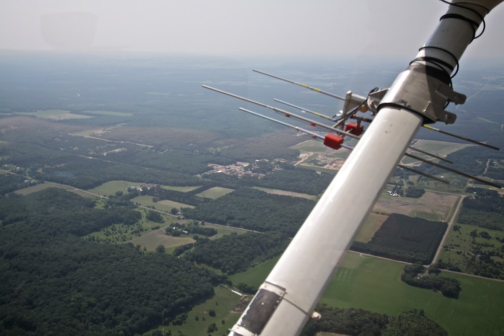
As our flight headed east, the first wolfs’ transmission was quickly picked up very near its previous GPS position.  Each wolf (and crane or other surveyed animal) have a GPS waypoint from their last known fix, making it easier to quickly find a signal.  It’s pretty amazing to see Beverly fly the plane, flip switches between two antennas on either wing, cradle the transceiver adjusting squelch (sensitivity to a signal), punch in a new GPS point and hand write a note in her observation folder….almost all at the same time.  Dropping altitude and circling tighter usually was rewarded with a comment like “Yep-he’s right under us.” Or “somewhere in that patch of pine.”  Slight nudges of the pedals or a touch to the yoke, set us on course to the next wolf.

If it’s only a weak transmission-perhaps from an old collar and batteries, we’d ascent higher to try and catch the cone-like signal to narrow in on the location.  Dropping down low would then pinpoint the exact spot within a hundred yards or closer.  I’d not flown in such a small craft like Paulan’s  Cessna 172 but tolerated the ever tightening steeply banked turns required to hone in on a fix-kinda fun, actually!

Flying at just 3000 feet above the landscape was such a great perspective-particularly since part of our flight was over county forest I know well.  Seeing trails, forest roads and wetlands from above kept my head glued to the window, camera at the ready.  Recording one wolf location after another, we continued south east and made a slight detour to check on a whooping crane occupying a nest.  The bright white speck was easy to pick out from the surrounding lush green marsh, and it’s posture told Beverly that the eggs were not hatched as of yet.  Both male and females will help incubate the eggs she added.  Trying to photograph from the plane proved to be difficult- a lot of movement and we did stand off a bit so as not to disturb the nest.

Two wolves occupy territory within the Air National Guard’s Hardwood bombing range and surrounding wildlife area south of Babcock, and yes, animals have been lost here because of military training.  Beverly radioed ahead to Camp Douglas to confirm the range was not” hot” (open for training) and safe to enter.  It was rather odd to see tanks, containers and aircraft randomly scattered in the thick forest below in various stages of destruction.  Apparently, it still can be home for wildlife, as the two wolves here were found and we headed back out. I wished inside, they’d perhaps move to a safer habitat. 

The newly collared wolves were pinpointed and I perceived some relief from Paulan, “It’s always comforting to get that first signal after collaring, a strong signal tells us everything is working well.”  I was surprised how far one of them had moved-maybe 4 or 5 miles from the capture site.  “Actually, I’m happy to see them on the move like that-it tells us they are healthy and doing well.” commented Paulan.  Sometimes successive flight observations can also help gauge how they are recovering from an injury, for instance.  One subject, who had suffered leg trauma, visibly could not use that limb at first.  Each week, Paulan observed him recover slowly, a limp, then gradually full use of leg.  It also told researchers that he was with a supportive pack or he would not have survived.

Our return flight took us over the Sandhill Wildlife Area, where we had a chance to observe bison settling down in their sand wallows-the giant animals easy to pick out below.  Small flowages I’d duck hunted in many years past were nearby and I recognized some here within Sandhill.  It was amazing how quickly you can get from point A to point B in this small plane, yet we were only traveling at 90 or so knots.  Landscapes take on a whole new look, the topography isn’t always obvious.  I’d pick out features like the Black River, Lake Arbutus or Lake Eau Claire to get my bearings-Beverly used major road ways.  Near Augusta, one easy landmark contrasting from the surrounding Amish farms was a massive frac sand mine with a mile plus conveyor moving sand to a plant and rail road spur.  From the air the huge holding ponds nestled right next to small farms and cropland could easily be distinguished.  How the influx of these mines must have changed the living environment here.

After gently setting down back in Eau Claire, we had a chance to review parts of the flight, their profession as pilots and some like minded discussion on wide ranging topics, from hunting to public service careers.  What became clear is that for Paulan, being a DNR pilot is not so much a job, but rather a calling-for she is just as passionate about the environment, outdoors and wildlife and their well being as she is about flying.  Although Armstrong said-  pilots like flying,” and Paulan does, she also takes very seriously why she is in the air and what her work provides for biologists, scientists and anyone who loves Wisconsin’s outdoors.


Smith: Tracking surveys remain critical part of DNR's gray wolf population estimate in Wisconsin

  Smith: Tracking surveys remain critical part of DNR's gray wolf population estimate in Wisconsin Tracking surveys by DN...